Undersea Features Volcanoes
-
Northern EPR at 9.8°N
-
Northern EPR at 10.7°N
-

Southern EPR at 18.2°S (Segment J)
-

Southern EPR at 17.5°S (Segment K)
-
CoAxial Segment
-
Southern EPR at 18.5°S (Segment I)
-
CoAxial Segment
-
Northern EPR at 9.8°N
-
Northern EPR at 9.8°N
-
Southern EPR at 18.5°S (Segment I)
-
Southern EPR at 18.2°S (Segment J)
-
Southern EPR at 18.5°S (Segment I)
-
Southern EPR at 17.5°S (Segment K)
Undersea Features has 16 Holocene volcanoes. Note that as a scientific organization we provide these listings for informational purposes only, with no international legal or policy implications. Volcanoes will be included on this list if they are within the boundaries of a country, on a shared boundary or area, in a remote territory, or within a maritime Exclusive Economic Zone. Bolded volcanoes have erupted within the past 20 years. Suggestions and data updates are always welcome ().
| Volcano Name | Location | Last Eruption | Primary Volcano Type |
|---|---|---|---|
| Axial Seamount | Juan de Fuca Ridge | 2015 CE | Fissure vent(s) |
| Cleft Segment | Juan de Fuca Ridge | 1986 CE | Fissure vent(s) |
| CoAxial Segment | Juan de Fuca Ridge | 1993 CE | Fissure vent(s) |
| East Blanco Depression | Blanco Transform Fault Zone | Unknown - Unrest / Holocene | Fissure vent |
| East Gakkel Ridge at 85°E | East Gakkel Ridge | 1999 CE | Fissure vent |
| Hollister Ridge | Udintsev Fracture Zone | Unknown - Evidence Uncertain | Fissure vent |
| Northern EPR at 10.7°N | East Pacific Rise | 2003 CE | Fissure vent(s) |
| Northern EPR at 9.8°N | East Pacific Rise | 2006 CE | Fissure vent(s) |
| Pico Fracture Zone | Atlantic Ocean (northern) | 1865 CE | Fissure vent |
| Romanche Fracture Zone | Atlantic Ocean (central) | Unknown - Evidence Uncertain | Fissure vent |
| Southern EPR at 17.5°S (Segment K) | East Pacific Rise | 1990 CE | Fissure vent(s) |
| Southern EPR at 18.2°S (Segment J) | East Pacific Rise | 1890 CE | Fissure vent(s) |
| Southern EPR at 18.5°S (Segment I) | East Pacific Rise | 1915 CE | Fissure vent(s) |
| Southern EPR at 8°S | East Pacific Rise | 1969 CE | Fissure vent(s) |
| Udintsev Transform | Udintsev Fracture Zone | Unknown - Evidence Uncertain | Fissure vent |
| Walvis Ridge at 33°S | Atlantic Ocean (central) | 2002 CE | Cone |
Chronological listing of known Holocene eruptions (confirmed or uncertain) from volcanoes in Undersea Features. Bolded eruptions indicate continuing activity.
| Volcano Name | Start Date | Stop Date | Certainty | VEI | Evidence |
|---|---|---|---|---|---|
| Axial Seamount | 2015 Apr 23 | 2015 May 24 ± 1 days | Confirmed | 0 | Observations: Seismicity |
| Axial Seamount | 2011 Apr 6 | 2011 Apr 12 | Confirmed | 0 | Observations: Reported |
| Northern EPR at 9.8°N | 2005 Aug 16 (?) ± 15 days | 2006 Jan 16 (?) ± 15 days | Confirmed | 0 | Observations: Reported |
| Northern EPR at 10.7°N | 2003 May 31 (?) ± 30 days | 2003 Oct 15 ± 21 days | Confirmed | 0 | Observations: Reported |
| Walvis Ridge at 33°S | 2001 Nov 24 | 2002 Mar 16 ± 15 days | Confirmed | 0 | Observations: Reported |
| East Gakkel Ridge at 85°E | 1999 Apr 5 (?) | 1999 Apr 15 (?) | Confirmed | 0 | Observations: Seismicity |
| Axial Seamount | 1998 Jan 25 | 1998 Feb 5 (?) | Confirmed | 0 | Observations: Reported |
| CoAxial Segment | 1993 Jun 26 | 1993 Jul 4 (?) | Confirmed | 0 | Observations: Reported |
| Northern EPR at 9.8°N | 1991 Dec 1 ± 30 days | 1992 Feb 4 ± 30 days | Confirmed | 0 | Observations: Reported |
| Northern EPR at 9.8°N | 1991 Mar 16 (?) ± 15 days | Unknown | Confirmed | 0 | Observations: Reported |
| Hollister Ridge | [1991 Mar 11] | [1991 Mar 19] | Uncertain | ||
| Udintsev Transform | [1990 Oct 29] | [1990 Nov 19] | Uncertain | ||
| Southern EPR at 17.5°S (Segment K) | 1990 Jul 2 ± 2 years ± 182 days | Unknown | Confirmed | 0 | Observations: Reported |
| Northern EPR at 9.8°N | 1988 Jul 2 ± 1 years ± 182 days | Unknown | Confirmed | 0 | Observations: Reported |
| Cleft Segment | 1986 Aug 16 (?) ± 15 days | Unknown | Confirmed | 0 | Observations: Reported |
| CoAxial Segment | 1986 Jul 2 ± 5 years ± 182 days | Unknown | Confirmed | 0 | Observations: Reported |
| Cleft Segment | 1982 Jul 2 (in or before) ± 182 days | Unknown | Confirmed | 0 | Observations: Reported |
| Axial Seamount | 1976 Jan 1 ± 6 years | 1982 (in or before) | Confirmed | 0 | Observations: Reported |
| Southern EPR at 17.5°S (Segment K) | 1965 Jul 2 (?) ± 182 days | Unknown | Confirmed | 0 | Correlation: Magnetism |
| Southern EPR at 8°S | 1964 Jul 2 (?) ± 182 days | 1969 Jul 2 (?) ± 182 days | Confirmed | 0 | Observations: Reported |
| Northern EPR at 9.8°N | 1950 Jul 2 (?) ± 182 days | Unknown | Confirmed | 0 | Correlation: Magnetism |
| Southern EPR at 17.5°S (Segment K) | 1930 (?) | Unknown | Confirmed | 0 | Correlation: Magnetism |
| Southern EPR at 18.5°S (Segment I) | 1915 ± 40 years | Unknown | Confirmed | 0 | Correlation: Magnetism |
| Southern EPR at 18.2°S (Segment J) | 1890 (?) | Unknown | Confirmed | 0 | Correlation: Magnetism |
| Northern EPR at 9.8°N | 1875 (in or before) | Unknown | Confirmed | 0 | Correlation: Magnetism |
| Pico Fracture Zone | 1865 Jul 9 | Unknown | Confirmed | 0 | Observations: Reported |
| Southern EPR at 18.5°S (Segment I) | 1860 (?) | Unknown | Confirmed | 0 | Correlation: Magnetism |
| Southern EPR at 17.5°S (Segment K) | 1840 (?) | Unknown | Confirmed | 0 | Correlation: Magnetism |
| Romanche Fracture Zone | [1836 Nov (in or before)] | [Unknown] | Uncertain | ||
| Southern EPR at 18.2°S (Segment J) | 1820 (?) | Unknown | Confirmed | 0 | Correlation: Magnetism |
| Romanche Fracture Zone | [1816 Dec 8] | [Unknown] | Uncertain | ||
| Romanche Fracture Zone | [1761 May 3] | [Unknown] | Uncertain | ||
| Northern EPR at 9.8°N | 1650 ± 100 years | Unknown | Confirmed | 0 | Isotopic: Uranium-series |
| Axial Seamount | 1650 ± 117 years | Unknown | Confirmed | 0 | Isotopic: 14C (calibrated) |
| Southern EPR at 17.5°S (Segment K) | 1625 (?) | Unknown | Confirmed | 0 | Correlation: Magnetism |
| Southern EPR at 18.5°S (Segment I) | 1620 (?) | Unknown | Confirmed | 0 | Correlation: Magnetism |
| Northern EPR at 9.8°N | 1600 ± 150 years | Unknown | Confirmed | 0 | Isotopic: Uranium-series |
| Axial Seamount | 1400 ± 71 years | Unknown | Confirmed | 0 | Isotopic: 14C (calibrated) |
| Axial Seamount | 1300 ± 91 years | Unknown | Confirmed | 0 | Isotopic: 14C (calibrated) |
| Axial Seamount | 1260 ± 72 years | Unknown | Confirmed | 0 | Isotopic: 14C (calibrated) |
| Axial Seamount | 1230 ± 76 years | Unknown | Confirmed | 0 | Isotopic: 14C (calibrated) |
| Northern EPR at 9.8°N | 1200 ± 300 years | Unknown | Confirmed | 0 | Isotopic: Uranium-series |
| Axial Seamount | 1000 ± 98 years | Unknown | Confirmed | 0 | Isotopic: 14C (calibrated) |
| Northern EPR at 9.8°N | 0950 ± 2000 years | Unknown | Confirmed | 0 | Isotopic: Uranium-series |
| Northern EPR at 9.8°N | 0850 ± 200 years | Unknown | Confirmed | 0 | Isotopic: Uranium-series |
| Axial Seamount | 0800 ± 107 years | Unknown | Confirmed | 0 | Isotopic: 14C (calibrated) |
| Axial Seamount | 0410 ± 123 years | Unknown | Confirmed | 0 | Isotopic: 14C (calibrated) |
| Northern EPR at 9.8°N | 0050 BCE ± 2000 years | Unknown | Confirmed | 0 | Isotopic: Uranium-series |
| Cleft Segment | 0270 BCE (?) | Unknown | Confirmed | 0 | Isotopic: Uranium-series |
| Northern EPR at 9.8°N | 1050 BCE ± 2000 years | Unknown | Confirmed | 0 | Isotopic: Uranium-series |
| Northern EPR at 9.8°N | 2050 BCE ± 2000 years | Unknown | Confirmed | 0 | Isotopic: Uranium-series |
| Northern EPR at 9.8°N | 3050 BCE ± 2000 years | Unknown | Confirmed | 0 | Isotopic: Uranium-series |
| Northern EPR at 9.8°N | 4050 BCE ± 2000 years | Unknown | Confirmed | 0 | Isotopic: Uranium-series |
| Northern EPR at 9.8°N | 5050 BCE ± 8000 years | Unknown | Confirmed | 0 | Isotopic: Uranium-series |
Undersea Features has 2 Pleistocene volcanoes. Note that as a scientific organization we provide these listings for informational purposes only, with no international legal or policy implications. Volcanoes will be included on this list if they are within the boundaries of a country, on a shared boundary or area, in a remote territory, or within a maritime Exclusive Economic Zone. Suggestions and data updates are always welcome ().
| Volcano Name | Location | Primary Volcano Type |
|---|---|---|
| Unnamed | Pacific Ocean (southern) | Cone |
| Vance Segment | Juan de Fuca Ridge | Fissure vent |
There are 13 photos available for volcanoes in Undersea Features.
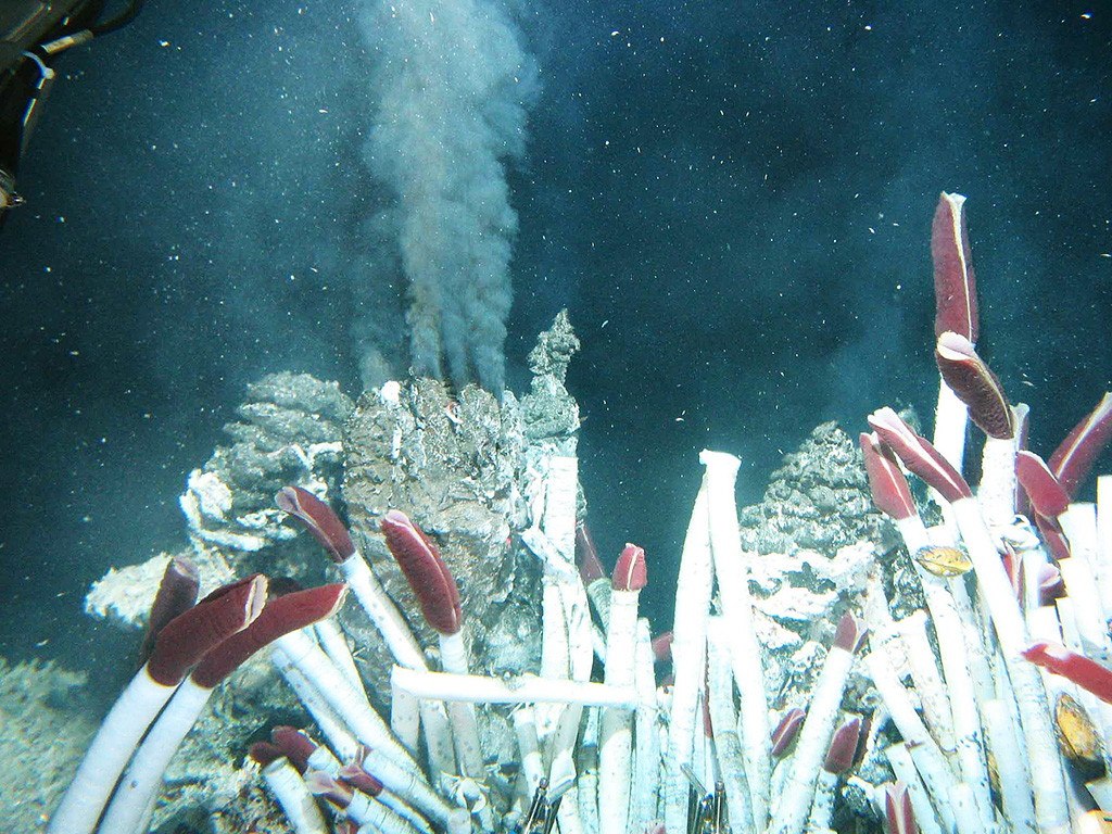
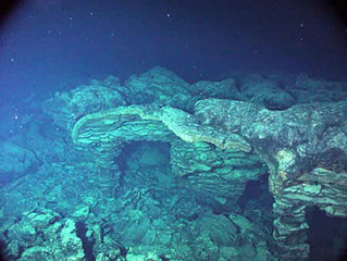
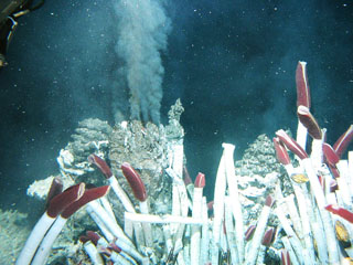
 Black smoker vents emitting low-chlorinity fluids at 374°C were photographed at the "RM28" site at 18°26’S on Segment I of the Southern East Pacific Rise in November 1994 from the Japanese submersible Shinkai 6500. The narrow axial crest of Segment I of the Southern East Pacific Rise in some places is less than 50 m wide. The largest lava flow field in this area is the Animal Farm flow, named after a thriving low-temperature hydrothermal site discovered during a 1993 submersible expedition.
Image courtesy of NOAA Vents Program, 1994 (www.pmel.noaa.gov/vents/chemistry/images/).
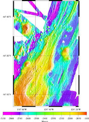
 An eruption in 2005-2006 that covered 23 km2 of sea floor with lava at the East Pacific Rise encased three ocean-bottom seismometers. Scientists successfully recovered two seismometers that were deployed in 2003 with the remotely operated vehicle Jason during a National Science Foundation/Woods Hole Oceanographic Institution expedition in April 2007.
Photo courtesy National Deep Submergence Facility, ROV Jason, Woods Hole Oceanographic Institution and National Science Foundation.
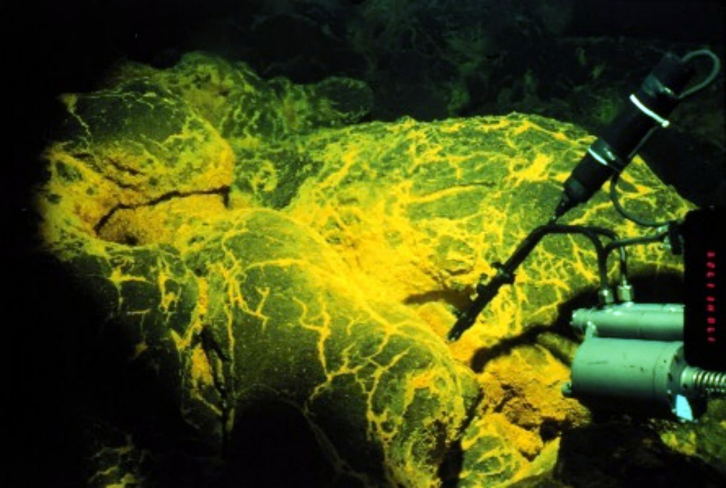
 During a 1993 ROPOS ROV (Remotely Operated Vehicle) dive on the CoAxial Segment along the Juan de Fuca Ridge a new lava flow was discovered on the sea floor. It was still hot and venting warm water (up to 50°C), and was 2.5 km long and 300 m wide. Bright yellow sediment patches indicated the presence of iron-reducing bacteria in the vent fluids. The CoAxial segment is located about 435 km W of the Oregon coast, NE of Axial volcano.
Image courtesy of National Oceanic and Atmospheric Administration (http://www.pmel.noaa.gov/vents/home.html).
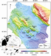 Detailed bathymetry of the East Gakkel Ridge at 85°E in the Arctic Ocean. The inset map shows the location of the 85°E segment (yellow star) along the Gakkel Ridge (red line). The main panel shows illuminated color bathymetry (30-m grid spacing) of the 85°E segment acquired during the AGAVE expedition. The axial valley contains large numbers of distinctive, cratered volcanoes, including a cone on a fault terrace of the northern valley wall. Named features include two volcanic ridges in the center of the axial valley (Jessica’s Hill and Duque’s Hill), and three cratered volcanoes along a ridge-parallel fissure to the south (Oden, Thor, and Loke). The bathymetry data were plotted with Generic Mapping Tools.
Sohn et al., 2008. Explosive volcanism on the ultraslow-spreading Gakkel ridge, Arctic Ocean. Nature, v. 453, p. 1236-1238.
 An eruption from the southern end of Axial caldera in 1998 produced this submarine lava flow that had undergone collapse, shown in this photo. Axial Seamount rises 700 m above the mean level of the central Juan de Fuca Ridge crest about 480 km W of Cannon Beach, Oregon, to within about 1.4 km of the ocean surface. The 3 x 8 km Axial caldera opens to the SE and is defined on three sides by caldera walls up to 150 m high. Hydrothermal vents colonized with biological communities are located near the caldera boundary or along the rift zones.
Photo courtesy of NOAA NeMo Observatory, 2006.
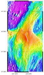
 The linear NE-SW-trending CoAxial Segment (center) of the Juan de Fuca Ridge is located about 435 km W of the Oregon coast. It lies NE of Axial volcano, which is in the bottom-left of this map. A submarine eruption along the CoAxial segment detected by acoustic hydrophones in June 1993 produced thermal plumes and a new lava flow. Bathymetric surveys indicated that one or more additional sea floor lava extrusions took place nearby sometime between 1981-82 and 1991.
Image courtesy of National Oceanic and Atmospheric Administration (http://www.pmel.noaa.gov/vents/home.html).
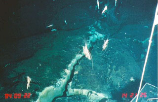 Shrimp swimming above a hydrothermally active vent within basalt on the Southern East Pacific Rise (near 17° 27’ S) were photographed in November 1994 from the Japanese submersible Shinkai 6500. Shrimp and crabs were seen going in and out of similar cracks in this area. Lava flows from a recent volcanic eruption were observed in 1994 along segment K of the Southern East Pacific Rise.
 Image courtesy of NOAA Vents Program, 1994 (www.pmel.noaa.gov/vents/chemistry/images/).
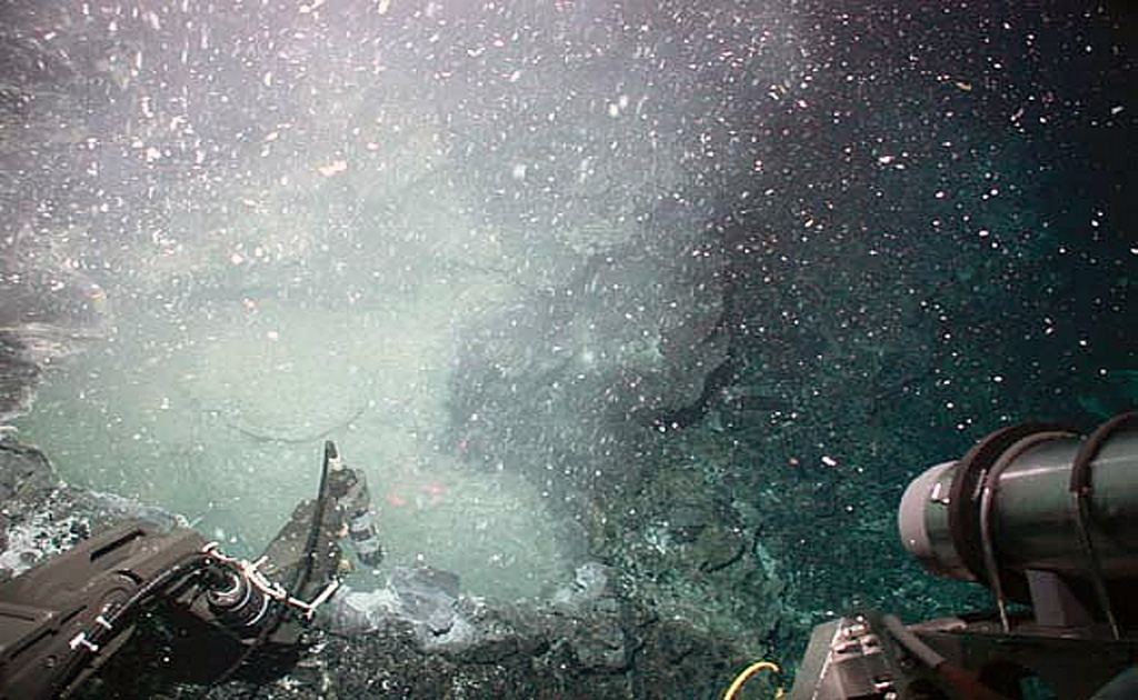
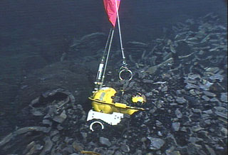
 A temperature probe from the submersible vehicle Alvin collects data at a low-temperature hydrothermal vent located in a collapse structure in the East Pacific Rise area. The maximum temperatures reached only 9.5°C. This lava flow was erupted within only a few weeks to a few months of this November 2003 expedition. The flow was covered by bacterial mats, had large amounts of bacterial floc issuing from diffuse vents, and was sparsely populated by small animals.
Photo courtesy J.R. Voight, 2003 (Ridge2000, National Science Foundation).
 Fluid containing precipitates rises from a "black smoker" chimney at the Tica vent at 9°N on the East Pacific Rise, photographed during a 2004 expedition sponsored by the National Science Foundation. Hot-vent animal communities (such as seen in the foreground of this image from the November to December 1989 expedition) were observed to have been buried by lava flows in 1991. Another eruption in 2005-2006 produced lava flows that covered seismometers.
Photo courtesy of Ridge2000, 2004 (http://www.ridge2000.org/eo/expeditions.php).
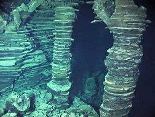 Lava pillars supporting the upper crust remain after collapse of a lava flow that erupted from Axial volcano in 1998. The layers within the lava formed when ponded lava drained away. A seismic swarm was detected at Axial Seamount beginning on 25 January 1998. An oceanographic cruise during 9-16 February detected elevated hydrothermal plumes, and later mapping indicated that a submarine lava flow had extruded from a 9-km-long fissure system.
Photo courtesy of NOAA NeMo Observatory, 2006.
 Black smoker hydrothermal vents emitting high-chlorinity fluids were photographed at the "RM29" site at 18°10’S. This image was taken in November 1994 from the Japanese submersible Shinkai 6500. The axial crest of Segment J of the Southern East Pacific Rise consists of an asymmetrical shallow graben varying from 250 to 600 m wide with walls about 20 m high.
Image courtesy of NOAA Vents Program, 1994 (www.pmel.noaa.gov/vents/chemistry/images/).
 Axial volcano lies along the central Juan de Fuca Ridge crest about 480 km W of the Oregon coast. The summit reaches about 1.4 km below the ocean surface and is marked by a 3 x 8 km caldera (center). The caldera opens to the SE and has caldera walls up to 150 m high. Hydrothermal vents colonized with biological communities are located near the caldera boundary or along rift zones to the NE and S. In 1998 a lava flow was erupted from a fissure at the southern end of the caldera.
Image courtesy of National Oceanic and Atmospheric Administration (http://www.pmel.noaa.gov/vents/home.html).
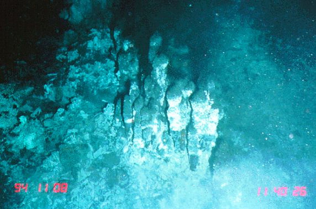
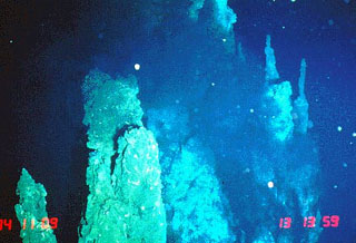
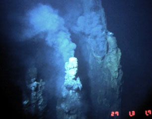 These black smoker vents are located along the Cleft Segment, the southernmost segment of the Juan de Fuca Ridge. These sustained high-temperature vents were photographed along fissures that fed an older lava flow adjacent to a 1986 lava flow that was erupted during the second of two documented submarine eruptions in the 1980s. The 80-km-long Cleft Segment is located immediately north of the Blanco Fracture Zone about 500 km off the Oregon coast.
Image courtesy of National Oceanic and Atmospheric Administration (http://www.pmel.noaa.gov/vents/home.html).
This is a compilation of Undersea Features volcano information sources, such as official monitoring or other government agencies.
| Volcanic Ash Advisory Center |
|---|